- Home Page /
- Electronics /
- GPS, Finders & Accessories /
- Sports & Handheld GPS /
- Handheld GPS Units /
- E1 RTK GNSS Survey Equipment GPS Receiver wit...
0 ratings




Item #:
84697072
E1 RTK GNSS Survey Equipment GPS Receiver with IMU Rover & Base Handheld Collector Land Surveying Equipment, Navigation System Survey
Item #:
84697072
MWK 9515506
Price Details
Excluding Shipping & Custom charges ( Shipping and custom charges will be calculated on checkout )
*All items will import from US
0 ratings
Write a review
In stock
 Imported from USA store
QTY:
Only 13 items left in stock.
Order now and get it around Sunday, August 02
Secured transaction
Ubuy works hard to protect your security and privacy. Our advanced payment security system ensures confidentiality by encrypting your information during transmission using AES (Advanced Encryption Standards) and SSL (Secure Socket Layer) protocols. Your payment details are 100% secure as we do not share your payment details with third party sellers.
Our Top Logistics Partners


E1 GNSS Receiver ensures centimeter-level accuracy in various terrains and has a durable, easy-to-use design with abundant transmission options.

Fast
Shipping

Free
Return*

Secure Packaging

100% Original Products

PCI DSS Compliance

ISO 27001 Certified


Note: Step Down Voltage Transformer required for using electronics products of US store (110-120). Recommended power converters Buy Now.


What Stands Out
Precision Accuracy
The E1 RTK GNSS GNSS receiver provides unparalleled precision, ensuring reliable measurements for surveying activities, significantly reducing errors compared to traditional methods.
Complete Kit
This product includes everything necessary for effective surveying—IMU rover, base station, and accessories—allowing users to start projects immediately without needing additional purchases.
User-Friendly Software
Equipped with intuitive navigation software, the E1 simplifies data collection and enhances user efficiency, making complex surveying tasks accessible to both beginners and experienced professionals.
Product Details
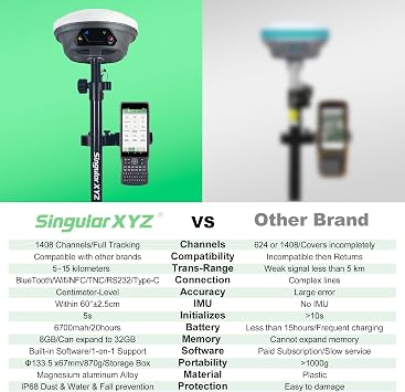
- 【15KM (9.32 miles) Radio】E1 GNSS Surveying System supports up to 15KM range in base-rover mode, unaffected by network or environment. Can also connect to CORS/NTRIP for centimeter-level accuracy.
- 【60°Tilt Surveying】E1 GNSS with IMU, can initializes in 5 seconds and supports tilt measurements up to 60°, and compatible with regular 5/8" thread poles.
- 【20 Hours Endurance 】E1 RTK GNSS provides 6700mah over 20 hours of continuous operation on a single charge, with fast Type-C charging. It employs a base station and rover with the (GPS) to attain Centimeter-Level Precision Measurement, High precision with low power consumption, small size easy to carry and operate.
- 【Various Interfaces】E1 gnss rtk innovative integration of multiple connection methods: NFC (Touch connection) /Bluetooth/USB Type-C/WiFi/TNC Connector/RS232 Serial Port. Easily access static data download, Configuration, device Status check, and Firmware Upgrade.Improve your work efficiency by 30%!!
- 【Robust Signal Tracking】E1 RTK support Full-Constellation Tracking: GPS/GLONASS/Galileo/BDS/QZSS/IRNSS/SBAS etc, an easily obtain fixed RTK solution in seconds even in challenging environments like multipath, trees, and city canyons.
- 【ABOUT US】SingularXYZ focuses on high precision GNSS PNT (Positioning, Navigation & Timing) technology, extending its coverage to geospatial information, precision agriculture, machine control, robotics, telecom, IoT and etc., providing reliable, stable and professional products and service, committed to popularizing precision and intelligence into all aspects of people's lives, contributing to the construction of an informatized, intelligent and efficient world.
- 【Support】Buyers can always contact the seller's tech team to ensure the gnss survey equipment works perfectly. Please refer to the manual included in the package, email us for technical support, or visit the SingularXYZ website to get in touch. We also offer video conference guidance to assist you.
- Note: U.S. users must apply for an FCC radio license for commercial use (e.g., surveying, construction) with the UHF function (450–470 MHz). The device is FCC certified, and we can provide supporting info if needed.
- 【Complete GNSS Surveying Kit】Includes E1 Base & Rover system, SC260 Data Collector, and tripod + pole + tribrach set, delivered in two packages: 48 × 22 × 41 cm (18.90 × 8.66 × 16.14 in), 8.90 kg (19.62 lb) and 109 × 22 × 21 cm (42.91 × 8.66 × 8.27 in), 5.70 kg (12.57 lb), providing a complete, stable and high-accuracy surveying solution.
| Compatible with Vehicle Type | Car |
| Screen Size | 1 Inches (2.5 cm) |
| Additional Features | Bluetooth, NFC, Waterproof |
| Connectivity Technology | Bluetooth, Ethernet, USB, Wi-Fi |
| Map Types | Worldwide |
| Audio Output Mode | Digital |
| Battery Average Life | 20 Hours |
| Mounting Type | Tripod Mount |
| Operating System | Android |
| Memory Storage Capacity | 8 GB |
| Touch Screen Type | Capacitive |
| Display Type | LCD |
| Human-Interface Input | Keyboard |
| Compatible Devices | Android Phone, Data collectors, Tablet |
| Control Method | App |
| Are Batteries Included | Yes |
| Supported Satellite Navigation System | BeiDou, GLONASS, GPS, Galileo |
| Connectivity Protocol | Bluetooth, UHF, Wi-Fi |
| Brand | SingularXYZ |
| Model Name | E1(1+1+Pole) |
| Built-In Media | E1 GNSS Receiver *2, Transport Case*2, USB-Type C Cable*2, Super Charger*2, Quick Start Guide*1, Quick Start Card*1, SC200 Data Collector*1, USB cable *1, Super Charger *1, Bracket*1, SingularPad Software*1, Whip Antenna*2, Tape Measure*1, 20 cm extention rod plugged on tribrach*1, 1.8m telescopic centering pole *1, Tribrach*1, Tripod*1 |
| Model Year | 2024 |
| Manufacturer | SingularXYZ |
| Model Number | SingularXYZ-E1(1+1+Pole) |
| Mfr Part Number | SingularXYZ-E1(1+1+POLE) |
| Item Type Name | E1 GPS RTK |
| Item Dimensions L x W x H | 8.67"L x 9.05"W x 41.34"H (22 x 23 x 105 cm) |
| Item Weight | 29.55 Pounds (13.4 kg) |
| Vehicle Service Type | Car |
| Special Feature | Bluetooth, NFC, Waterproof |
| Map Type | Worldwide |
| Included Components | E1 GNSS Receiver *2, Transport Case*2, USB-Type C Cable*2, Super Charger*2, Quick Start Guide*1, Quick Start Card*1, SC200 Data Collector*1, USB cable *1, Super Charger *1, Bracket*1, SingularPad Software*1, Whip Antenna*2, Tape Measure*1, 20 cm extention rod plugged on tribrach*1, 1.8m telescopic centering pole *1, Tribrach*1, Tripod*1 See more |
| Battery Life | 20 Hours |
What's in the box
E1 GNSS Receiver *2, Transport Case*2, USB-Type C Cable*2, Super Charger*2
SingularPad Software*1
SC200 Data Collector*1, USB cable *1, Super Charger *1, Bracket*1
Whip Antenna*2, Tape Measure*1, 20 cm extention rod plugged on tribrach*1, 1.8m telescopic centering pole *1, Tribrach*1, Tripod*1
Quick Start Guide*1, Quick Start Card*1
Who Should Buy?

-
Land Surveyors
Ideal for professional land surveyors needing accurate measurements and positioning for various surveying tasks.
-
Construction Companies
Beneficial for construction teams requiring precise location data for project planning and execution.
-
Research Institutions
Suitable for academic research in geography and environmental studies that require high-accuracy GNSS data.

-
Casual Users
Not suitable for recreational users who need simple location data without complex surveying features.
Product Description
Have any Query? Chat with us
Customer Questions & Answers
-
Question:
What is the E1 RTK GNSS Survey Equipment and how does it work?
Answer: The E1 RTK GNSS Survey Equipment is a precise GPS receiver designed for surveying. Utilizing Real-Time Kinematic (RTK) techniques, it delivers centimeter-level accuracy by leveraging satellite positioning data and a base station. The system includes an Inertial Measurement Unit (IMU) for enhanced positioning and motion detection. This setup is particularly useful in applications such as land surveying, construction, and agriculture, where exact measurements are crucial for planning and execution. -
Question:
What are the key features of the E1 RTK GNSS GPS Receiver?
Answer: The E1 RTK GNSS GPS Receiver boasts several key features: it includes high-precision RTK capabilities, an IMU for accurate motion tracking, a handheld collector for ease of use, and robust navigation system functions. These features make it incredibly versatile, suitable for various surveying tasks such as topographic surveys, boundary mapping, and agricultural planning. Its portability and user-friendly interface amplify its effectiveness, allowing users to collect and analyze data on-the-go. -
Question:
Can the E1 RTK GNSS Survey Equipment be used in challenging environments?
Answer: Yes, the E1 RTK GNSS Survey Equipment is designed to perform in challenging environments. Its advanced signal processing algorithms help mitigate issues caused by multipath effects and signal obstructions. This makes it ideal for urban areas, dense foliage, and varied terrains. For example, surveyors can effectively gather data in city landscapes or heavily wooded areas where traditional GPS equipment often struggles. -
Question:
Is training required to operate the E1 RTK GNSS equipment?
Answer: While no formal training is strictly required, understanding the basics of GNSS technology and field surveying can enhance your experience with the E1 RTK GNSS equipment. The user manual provides comprehensive guidance on operation and features, making it accessible for both beginners and experienced users. Practicing in the field is recommended to grasp the equipment's functionality fully, especially for complex surveying tasks. -
Question:
What accessories are recommended to use with the E1 RTK GNSS system?
Answer: Recommended accessories include a sturdy tripod for stable data collection, a field survey backpack for easy transport, and extra batteries for prolonged surveying sessions. Additionally, consider investing in a rugged screen protector for the handheld collector. These accessories enhance the usability and efficiency of the equipment, allowing for seamless operation in various environments. -
Question:
Does the E1 RTK GNSS Survey Equipment support data export?
Answer: Yes, the E1 RTK GNSS Survey Equipment supports multiple data export formats, including CSV and DXF, enabling users to easily transfer survey data to other applications for further analysis or project integration. This feature is essential for professionals in GIS, land surveying, and construction, allowing them to share insights and findings effortlessly with clients and collaborators. -
Question:
What maintenance does the E1 RTK GNSS Survey Equipment require?
Answer: Regular maintenance for the E1 RTK GNSS equipment includes checking for software updates, calibrating the IMU if necessary, and ensuring the antennas are free from obstructions or damage. Routine cleaning of the handheld collector and occasional inspection of connectors can prolong the lifespan of the equipment. Proper maintenance ensures high performance and reliability in critical surveying tasks. -
Question:
What is the warranty period for the E1 RTK GNSS Survey Equipment?
Answer: The warranty for the E1 RTK GNSS Survey Equipment typically spans one year, covering manufacturing defects and performance issues. Some manufacturers may offer extended warranty options for purchase. Keeping the purchase receipt and following the manufacturer's care instructions will help facilitate warranty claims, providing peace of mind for your investment in surveying equipment. -
Question:
Are there software options available for the E1 RTK GNSS survey data?
Answer: Yes, various software options can process and analyze data from the E1 RTK GNSS Survey Equipment. Popular choices include GIS software like ArcGIS and surveying tools such as AutoCAD. These applications allow users to visualize survey data, prepare reports, and make informed decisions. Integrating this software into your workflow streamlines project efficiency and data management. -
Question:
Where can I buy the E1 RTK GNSS Survey Equipment in Malawi?
Answer: You can purchase the E1 RTK GNSS Survey Equipment from Ubuy, a reliable online retailer that offers a wide selection of surveying and GPS equipment in Malawi. Ubuy provides detailed product descriptions, customer support, and various shipping options to ensure a smooth buying experience. Check out their website to explore availability and make your order.
SingularXYZ Handheld GPS Units SingularXYZ-E1(1+1+Pole) Editorial Review
No editorial reviews found
Customer Reviews & Ratings
9 customers ratings
-
5 Star
71%
-
4 Star
14%
-
3 Star
15%
-
2 Star
0%
-
1 Star
0%
Review this product
Share your thoughts with other customers
Platform Trust & Buyer Confidence

MT
Mohd
Verified buyer
“The product received very good packaging & safe…Thank You”
16 June 2026 · via Trustpilot
SJ
Shawati
Verified buyer
“Accurate delivery timing given”
16 June 2026 · via Trustpilot
YB
Youcef
Verified buyer
“Not madly expensive like I thought, and much quicker than promised.”
15 June 2026 · via Trustpilot
LM
Leila
Verified buyer
“Never dealt with Ubuy before, but everything worked out great. Seamless cross border purchasing and shipping. Thanks!”
6/7/2026 · via Trustpilot
KA
Kwame
Verified buyer
“The process was smooth, with clear communication and timelines. This was my 1st purchase and I am really impressed. I will definitely be coming back.”
12 June 2026 · via Trustpilot
Secure Checkout
Global Delivery
Easy Returns
Genuine Products
Product Price History
Important information
- Limitations : For products shipped internationally, please note that any manufacturer warranty may not be valid; manufacturer service options may not be available; product manuals, instructions, and safety warnings may not be in destination country languages; the products (and accompanying materials) may not be designed in accordance with destination country standards, specifications, and labeling requirements; and the products may not conform to destination country voltage and other electrical standards (requiring use of an adapter or converter if appropriate). The recipient is responsible for assuring that the product can be lawfully imported to the destination country. When ordering from Ubuy or its affiliates, the recipient is the importer of record and must comply with all laws and regulations of the destination country.
- Not all the products listed on Ubuy are for sale, as Ubuy is a global search engine. Products are subject to export/trade regulations.
MWK 9515506
Order now and get it around Sunday, August 02
This item is not restrict in my country.(Please click on above link if this item is not restrict in your country, So our team will review and allow.)
QTY:
Only 13 items left in stock.
Secured transaction
PCI DSS compliant and ISO 27001:2022 certified, with encrypted payments and full buyer protection on every order.
Our Top Logistics Partners
Fastest cross-border delivery
Features & Benefits
- Centimeter-level accuracy in forests and city canyons
- Compatible with third-party field software
- Sunlight-readable touch screen with integrated 4G/WiFi/Bluetooth
- Smaller, lighter, and durable design with IP68 protection
- Fast charging and long battery life for over 20hrs continuous working time
- Optimized IMU module for quick tilt measurements up to 60°
Ubuy Assurance
Experience worry-free shopping with 100% original products, PCI DSS-compliant payment security, ISO 27001-certified data protection, the fastest cross-border delivery, free returns *, and secure packaging on every order.